Bid for Earthquake Relief! The Monolith of Grey Whale Cove #2 - San Mateo County, California, a photo by PatrickSmithPhotography on Flickr.
California.
:)
Update: Auction Closed! A link will be sent to the winners as soon as you send me the screen grab! Thanks to the following winners:
aimeeern
KarremanPhotography.com
Brandon Lyons
mjmalone54
Gary Ngo Photography
Kevin_Mitchell
dm|ze
rvanr
LWach
--------- Original description ----
Again, I am entering this image in to the Flickr group Charity Print Auctions - Japan for Tsunami and earthquake relief. All proceeds will go to Japan via the British Red Cross or your favorite local Red Cross for your tax writeoff. The last in my stream photo went for USD $450.00. Now, I want to try something new to raise money.
This will be an auction for a full resolution (5616w x 3744h) jpg file created untouched from my original 125MB TIFF file, so there will be no degradation of the TIFF quality. It will be for your own personal use and can be printed BIG! No selling to other people or I'll find out...hehe! The top 10 bidders will be the winners. In case of a tie, the first bids will be chosen first.
See the 1400 pixel version here: (the big one looks much better!)
www.flickr.com/photos/patrick-smith-photography/553865237...
A video showing the magnitude of the damage:
www.youtube.com/watch?v=Rj-8Lhgv3nk
-------------------
To Bid:
-------------------
You need to make a comment below the image with the amount that you would like to bid in US $. When the auction closes, the 10 people with the highest bids win. The auction will close this coming Friday, March 25th at 8pm California time. To see the bidding, just read the comments!
The winning bidders will pay the amount they promised to their local Red Cross. For example:
www.redcross.org.uk/Donate-Now/Make-a-single-donation/Jap...
When you have made your donation, you MUST make a screen grab of the donation confirmation page to send to me for confirmation. This is the only way that I can know that you have paid. Then I will send you a link to the jpg file.
It is easy to make a screen print, see here!
take-a-screenshot.org/
---------------------------------------------------------
-- now for the usual description ----
---------------------------------------------------------
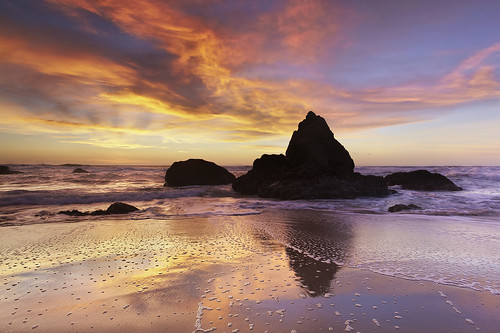
The second in the series. A low tide at sunset during the winter time is the only time when this view can be seen. Usually this is underwater and large waves pass through submerging this place under 5-10 feet of water. I've been waiting a long time to capture this scene. No HDR
---------------------------------------------------------
Details:
---------------------------------------------------------
Canon 5D mark II
Canon 17-40 @ 23
1/8-sec. exposure @F10
ISO 200 (to keep the exposure to 1/8, I wanted just a little movement)
2 LEE ND soft-edge grad 0.9s (the big ones)
Lee filter foundation kit (for an onobstructed wide view at < 22mm)
No polarizer.
RAW file processed with Capture One by Phase One
TIFF file processed with Photoshop cs4
Small Slik Sprint mini II tripod
Manfrotto 322RC2 pistol-grip ball head
----------------------------------------------------------------------------------
The Story (repeated from version #1)
----------------------------------------------------------------------------------
Grey Whale Cove, about 20 miles south of San Francisco is an excellent beach for photography and for just playing around. Yesterday afternoon was warm and sunny (75f, 24c at sunset) with some high thin clouds which are best for creating those brilliant red sunsets just as the sun drops below the horizon. This evening did not disappoint.
Be careful what you ask for. I was hoping that these clouds would make a red sunset, but the camera had a a tough time with it. It was incredible to see with my own eyes but the reds were getting blown out and the clouds were turning into red featureless blobs. So I had to move into a position where I was pointing away from the sun and then angle two strong grads over the bright parts on the left side of the sky. Most of this picture is not darkened by the grads at all, just the bits in the upper left. And even then, I had to desaturate the reds a bit in Photoshop to get back the detail. For that, I selected the red parts of the sky, feathered the selection, chose the red channel in Levels, and lowered the brightness.
There are lots of elements here that are difficult to capture all at once. Winter is the only time to get light on the monolith rock because the sun sets to the left of the frame. During the rest of the year, the sun sets behind the rock, making it a silhouette.
Another element is that it must be a very low tide in order to get into this spot because there is a cliff right behind me with limited escape options. (This was a 0.0 ft. tide. A minus tide might be even better but the waves would not be there.) And this beach has a habit of sending these sleeper wave surges in avery 5 minutes or so. Just when you get used to the patterns of the waves, a surge will come in and the water rises about 4-5 feet even with small waves. So you have to look constantly out to sea to give yourself time to prepare for a quick escape!
Other elements include that I waited for the sand to become reflective so capture the relection of the monolith rock and for a wave to strike the rock. And I wanted to show a big wave in the distance. About 20 seconds later, that wave flooded this area quite efficiently I must say!
The map shows the exact location.
---------------------------------------------------------------------
Other stuff
---------------------------------------------------------------------
My pictures are featured on the front page of the
state Government. of California website and the new Governor, Jerry Brown's website too. Have a look! It is Flash with my pics cut into layers for a 3-d slideshow. If you are into building apps, the State has opened up lots of data to the public, so check it out!
----------------------------------------------------------------------
Resources:
----------------------------------------------------------------------
A great weather mashup map of the world with local temperatures, weather and nice popups. See where it is hot and not!
www.wunderground.com/wundermap/
Google Earth
earth.google.com/
Simply the best way to scout out locations that there is. You can see sun angles and pre-visualize light under lots of different conditions. Sometimes you can actually pre-compose your shots! This has saved me many thousands of vertical feet of climbing by avoiding spots with blocked views etc.
Satellite imagery (choose 'National' for a local US region or use your fave website)
www.wrh.noaa.gov/satellite/?wfo=mtr
Tide charting and preditions: (chose your area in US, other countries have similar websites)
tidesandcurrents.noaa.gov/tide_predictions.shtml?gid=235
Wave Heights (I choose 'North Pacific from Global')
polar.ncep.noaa.gov/waves/main_int.html
Or Here:
www.opc.ncep.noaa.gov/shtml/RP1bw.gif
Photos of every inch of the California coastline from a small plane. Excellent for close in detailed views.
www.californiacoastline.org/
ad.


